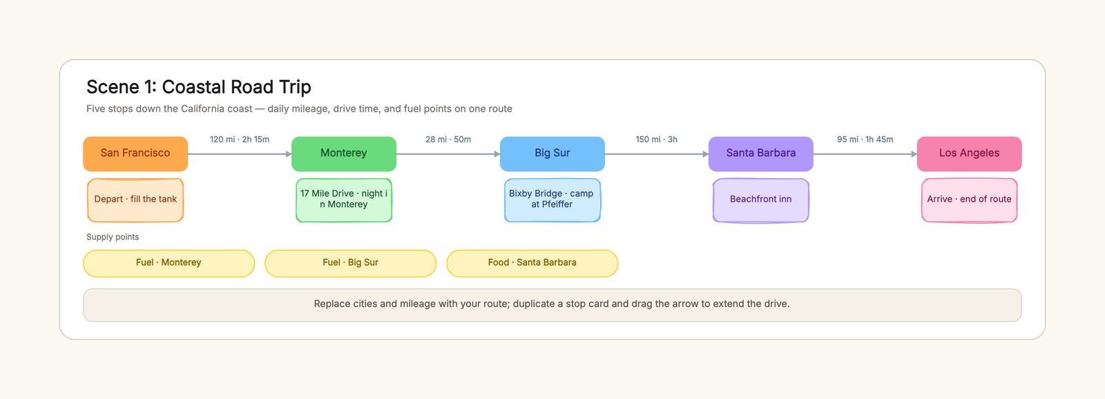
A road trip planner is what keeps a "let's just drive and see" trip from turning into a four-hour argument about whether the next gas station exists. It turns a vague plan into a line of stops, each with a mileage and a drive time, so you can see which days are too long before you are committed to them.
This guide walks through how to plan a driving route in five steps, then shows the three shapes it takes for a coastal drive, a mountain loop, and a cross-state long haul. You can adapt the road trip planner template and edit the stops, mileage, and fuel points directly in the browser.
What a road trip planner should map
A road trip is not a list of cities. It is the miles between them, and the miles are where the trip falls apart. A workable route should answer four questions: where you start, where you stop each night, how long each leg takes to drive, and where you can refuel and eat along the way.
A useful planner should produce a route that:
- shows every leg's mileage and drive time, not just the distance;
- marks an overnight card for every stop so you always know where the day ends;
- spaces fuel and food points no more than a tank apart;
- flags the legs that are too long for one day;
- is easy to share with whoever else is in the car.
Avoid treating every trip as the same length. A coastal drive runs on short legs and good food stops, a mountain loop runs on slow climbs and pass closures, and a long haul runs on fuel spacing and driving shifts. Start from the same route backbone and branch where the drive genuinely differs.
How to plan a road trip route in 5 steps
The most useful route is built back to front: decide the start and end first, then fill the stops, then check the legs are actually drivable.
1. Pin the start and end
Write your start and end points, then drop the stops in between. The end point matters first because it sets the total distance, which tells you how many days the trip needs before you choose any stops.
2. Give each stop an overnight card
Every stop gets a city and a lodging note — even a stop that is just "fuel and keep moving." When a leg runs long or the weather turns, the overnight card is the difference between a decision you made in advance and a late-night search on your phone.
3. Label every leg with mileage and drive time
Distance alone hides the slow roads. A 120-mile leg over a mountain pass takes twice the time of the same distance on the interstate. Label each leg with both numbers so the long days show up while you can still fix them.
4. Add the supply points
Fuel and food are the part of a road trip people plan last and regret first. Estimate practical range from the specific vehicle, load, terrain, weather, and a conservative reserve, then place verified fuel or charging options before that limit. Remote legs need earlier backups, not a universal distance rule.
5. Read the route in order and trim
Read the route top to bottom and look for any leg over about six hours of driving. Cut a long day by moving an overnight stop earlier, or split it into two. The route should read the way you would actually drive it.
Coastal road trip example
A coastal route is the easiest to overpack with stops, because everything looks close on a map. The classic California coast run — San Francisco to Los Angeles — is about 440 miles of slow, scenic highway that takes two full days when you stop for the views.
The legs stay short: San Francisco to Monterey is about 120 miles and two hours fifteen, Monterey to Big Sur is a 28-mile, fifty-minute stretch along the cliffs, and Big Sur down to Santa Barbara is the long one at about 150 miles and three hours. The trick is marking the fuel and food points at Monterey and Big Sur, because the coast has long gaps between gas stations and the last thing you want is to nurse the tank through Big Sur.
The coastal mistake that costs the most is assuming the ocean views mean you will make time. You will stop. Build the stops into the route and keep each day to three or four hours of driving.
Mountain road trip: what changes
A mountain loop changes the math on every leg. The Rocky Mountain loop from Denver over Trail Ridge Road to Aspen is only about 360 miles in total, but the legs are slow: Denver to Estes Park is 66 miles at an hour and a half, and the climb to Trail Ridge — a pass at 12,183 feet — turns 48 miles into an hour forty-five of switchbacks.
Altitude and passes are why you add buffer time to every mountain leg. The pass may be open in the morning and closed by afternoon weather, so the route needs a fallback overnight stop. Supply points sit near the gateway towns — Estes Park and Grand Junction — because there is nothing between them but the road itself.
The mountain mistake is planning the loop the way you would plan the coast. Slow the drive-time estimates down and check pass closures before you commit the route to the map.
Cross-state long haul: what changes again
A cross-state drive is a fuel and fatigue problem more than a scenery problem. The Chicago-to-Flagstaff section of a Route 66 drive stretches about 1,670 miles across four states, so the route becomes a series of 300-mile legs: Chicago to St. Louis is 297 miles and four and a half hours, St. Louis to Tulsa is 398 miles and six, and the pattern repeats down through Amarillo and Albuquerque.
On a long haul, the overnight card and supply plan do most of the work. Mark a primary and backup fuel or charging stop within the vehicle's conservative range, and agree on driver changes before departure. A route that doubles as a responsibility chart makes fatigue visible instead of leaving the decision to an already tired driver.
Road trip packing: what rides in the car
A road trip planner handles the route; a road trip packing list handles the stuff. The two overlap in one place: the car kit. A charger for every seat, a paper map for the dead zones, water and snacks for the long legs, and the documents — license, registration, and insurance — that stay with the driver, not buried in the trunk.
Keep a small overnight bag separate from the main luggage so a late arrival does not mean unpacking the whole car at a motel at midnight. Pack the emergency basics — a spare tire check, jumper cables, and a first-aid kit — before the route, not after the first breakdown. For the fuller list, the packing checklist template gives you a structure to start from.
Common road trip planning mistakes
Planning miles without drive time
Two legs with the same mileage can take very different times on a pass or in traffic. Label every leg with both numbers so the long days show up early.
Skipping the fuel stops
A long rural leg with no fuel point is where road trips stall. Mark fuel and food on the route and keep them no more than a tank apart.
No overnight card per stop
Stops without a lodging note turn into late-night searches. Give every stop an overnight card so you always know where the day ends.
One driver, one sitting
A six-hour leg with a single driver is a fatigue risk. Mark driving shifts and overnight stops on a long haul instead of pushing through.
Ignoring the season and passes
A mountain route that works in July may be closed in November. Check pass closures and weather before you commit the route.
Freeze the plan, then check live conditions
Save an offline copy with addresses, reservation numbers, emergency contacts, and the next safe stopping option for each leg. On departure day, verify closures, weather, fuel or charger availability, and lodging directly with current providers. If a leg loses its buffer, shorten it instead of borrowing time from rest. The planner sets decisions and fallback points; live navigation and official alerts govern the drive.
Keep the route useful on the road
Review the route after the trip and note which legs were too long or too short, so the next trip starts from a better map. Keep a short version — the overnight stops and the fuel spacing — in your notes, and reuse the full route next time. A road trip you review once is a drive you only white-knuckle once.
Start with the road trip planner template, replace the cities and mileage with your own route, and check the supply points before you pull out of the driveway. For the daily activities at each stop, the travel itinerary template fills in the schedule between the drives, and for the overnight stops that involve a tent, the camping checklist template covers the gear.